
Hoe nauwkeurig is GPS is een zeer goede vraag wanneer u met GPS wilt gaan landmeten. Wanneer u landmeet wilt u namelijk wel dat de resultaten nauwkeurig en precies zijn.
Een veelgestelde vraag is daarom: hoe nauwkeurig is GPS? Het enige correctie antwoord op de vraag hoe nauwkeurig GPS is is dat dit afhangt van veel factoren en dat de nauwkeurigheid ligt tussen een centimeter en enkele decimeters. De factoren die invloed hebben zijn onder meer het aantal satellieten waarvan de GPS ontvanger satellietsignalen ontvangt en de positie hoe de satellieten staan ten opzichte van de GPS ontvanger. Wanneer de nauwkeurigheid van de GPS ontvanger op centimeterniveau zit, dan is dit een RTK fix. Ook de andere nauwkeurigheidsniveaus hebben een naam. Voor het landmeten met GPS is echter een RTK fix noodzakelijk, omdat anders de resultaten van de inmeting niet nauwkeurig genoeg zijn. Deze RTK fix bij GPS landmeten kan onder meer worden verkregen door het gebruik van NTRIP of een lokaal basis station.
Om alles duidelijk te maken over dit onderwerp zullen we in dit artikel de volgende vragen beantwoorden:
- Wat is de nauwkeurigheid van GPS?
- Welke factoren hebben invloed op de nauwkeurigheid van GPS?
- Welke verschillende nauwkeurigheidsniveaus van GPS zijn er?
- Wat is de benodige nauwkeurigheid voor het landmeten met GPS?
- Hoe wordt het verschil in nauwkeurigheid tussen een GPS navigatiesysteem en GPS meetapparatuur verkregen?
Hoe nauwkeurig is GPS?: de oplossing
Het kan zo zijn dat u niet in de gelegenheid bent om dit gehele artikel te lezen. Daarom is er nog een mogelijkheid om meer te weten te komen over Hoe nauwkeurig is GPS?.
U kunt via deze website een GPS meetsysteem proberen. U kunt dan zelf zien hoe nauwkeurig GPS is. Kijk daarvoor direct op deze pagina.
U kunt op dezelfde pagina een demonstratie aanvragen van één van onze GPS meetsystemen. Bij deze demonstratie kunt u dan ook gerichte vragen stellen over hoe nauwkeurig GPS is en natuurlijk ook over andere onderwerpen met betrekking tot GPS landmeten.
Mocht u geen tijd hebben voor een demonstratie of wilt u snel tussendoor de software van onze GPS meetsystemen proberen dan is dat mogelijk. Apglos Survey Wizard is de eenvoudigste software om GPS metingen mee uit te voeren. U kunt deze gratis downloaden van de Google Play Store.
De landmeetapp Apglos Survey Wizard heeft volledige functionaliteit met de GPS van uw Android apparaat. U kunt deze app dus volledig testen en het is gratis.
Natuurlijk is de nauwkeurigheid van onze GPS ontvangers beter dan die van de standaard Android apparaten. Maar daar leest u op deze pagina dus alles over. Mocht u daarom een test willen doen met een nauwkeurig GPS systeem, kijk dan op deze pagina.
Wat is de nauwkeurigheid van GPS?
Hoe nauwkeurig is GPS? is een veelgestelde vraag. De vraag stellen is makkelijker dan deze te beantwoorden. GPS is namelijk niet altijd even nauwkeurig.
Waarschijnlijk heeft u wel eens genavigeerd met Google Maps. En op Google Maps kunt u zien met een blauwe punt waar u bent. Echter in de Android app Maps Go van Google ziet u ook een groot blauw rond vlak rondom dit punt.
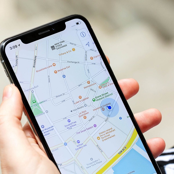
Dit blauwe ronde vlak geeft de onnauwkeurigheid weer. Hoe groter het ronde vlak, hoe groter de kans is dat de blauwe stip niet exact de locatie is waar u bent.
Mocht u een andere app voor navigatie gebruiken dan zult u waarschijnlijk wel eens uw positie zien verspringen. Ook dit geeft de onnauwkeurigheid aan van GPS.
Zoals u in uw navigatie app kunt zien is de nauwkeurigheid van GPS niet absoluut. Deze kan op een telefoon verschillen van enkele meters tot enkele decameters. Echter met GPS meetapparatuur kan een nauwkeurigheid worden behaald van nagenoeg een centimeter.
Welke factoren hebben invloed op de nauwkeurigheid van GPS?
En daar is al een factor met betrekking tot de nauwkeurigheid van GPS. GPS meetapparatuur heeft namelijk een grotere antenne, dan een GPS in een telefoon. Hierdoor kan GPS meetapparatuur meer en makkelijker satellietsignalen ontvangen.
En hoe meer satellietsignalen worden ontvangen hoe nauwkeuriger de positie met GPS kan worden bepaald. Dat is ook een van de redenen waarom de GPS meetapparatuur vaak op een meetstok van 2 meter of hoger wordt geplaatst.
Door het plaatsen van de GPS ontvanger op een hoge stok heeft de GPS ontvanger minder last van obstakels. En wanneer er minder last is van obstakels kan de GPS ontvanger meer satellietsignalen ontvangen en dus nauwkeuriger de positie bepalen.
Obstakels voor GPS meetapparatuur en GPS in het algemeen zijn bijvoorbeeld hoge bomen en gebouwen. De satellietsignalen komen niet door deze obstakels. Hierdoor kan de GPS ontvanger de geblokkeerde satellietsignalen niet ontvangen. Daardoor is het lastiger voor de GPS ontvanger om een exacte positie te bepalen.
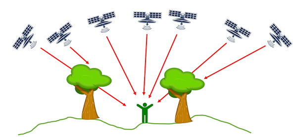
Maar naast de hoeveelheid satellietsignalen die de GPS ontvanger ontvangt is ook de positie van de satellieten ten opzichte van de GPS ontvanger van belang. Wanneer alle satellieten aan één kant van de GPS ontvanger staan dan is het voor een GPS ontvanger moeilijker om een nauwkeurige positie te bepalen.
Een goede spreiding van de satellieten is dus van belang voor de nauwkeurigheid van GPS. Gelukkig komen er steeds meer satellieten in een baan rondom de aarde, waarmee GPS ontvangers een positie kunnen bepalen.
Eerst waren er alleen GPS satellieten. Maar inmiddels zijn er nu ook satellieten van GLONASS, GALILEO en BEIDOU.
Een andere factor die invloed heeft op de nauwkeurigheid van GPS is de atmosfeer. De satellietsignalen gaan van de satellieten door de atmosfeer naar de GPS ontvanger. De atmosfeer is niet altijd gelijk. Hierdoor is er enige verstoring van de satellietsignalen. Door deze verstoring kan de positie zonder hulpmiddelen niet exact met GPS worden bepaald.
Welke verschillende nauwkeurigheidsniveaus van GPS zijn er?
Echter voor navigatie is de nauwkeurigheid van de positiebepaling met GPS zonder hulpmiddelen vaak ruim voldoende.
Dit is ook logisch, omdat deze nauwkeurigheid vaak rond de decameter ligt. En aangezien een weg meestal zo’n 5 à 6 meter is en er direct naast geen andere weg ligt kan de navigatie makkelijk bepalen op welke weg u rijdt.
Voor landmeten is een grotere nauwkeurigheid nodig. Hieruit blijkt al dat er verschillende nauwkeurigheidsniveaus zijn voor GPS.
Het mooie aan GPS is dat het zelf aangeeft hoe nauwkeurig de positie is. Dit doet de GPS ontvanger, maar ook uw telefoon in de taal van GPS oftewel NMEA. NMEA hoe GPS de positie communiceert met andere apparaten.
Een belangrijke regel van NMEA is de GGA regel. Deze regel geeft de positie weer, maar ook de nauwkeurigheid. Een GGA regel ziet er alsvolgt uit:
$GPGGA,172814.0,3723.46587704,N,12202.26957864,W,2,6,1.2,18.893,M,-25.669,M,2.0,0031*4F
De verschillende gegevens in een GGA regel worden gescheiden door het ,-teken. Wanneer u dat voor de bovenstaande regel doet dan krijgt u het volgende:
| Nummer | Voorbeeld | Betekenis |
| 1 | $GPGGA | Type NMEA regel |
| 2 | 172814.0 | De standaardtijd gebaseerd op de atoomklok |
| 3 | 3723.46587704 | Latitude |
| 4 | N | De richting van de latitude |
| 5 | 12202.26957864 | Longitude |
| 6 | W | De richting van de longitude |
| 7 | 2 | De kwaliteitsindicator van de GPS positie |
| 8 | 6 | Het aantal satellieten dat de GPS ontvanger gebruikt |
| 9 | 1.2 | HDOP |
| 10 | 18.893 | De orthometrische hoogte |
| 11 | M | De eenheid van de orthometrische hoogte |
| 12 | -25.669 | De geoïdale separatie |
| 13 | M | De eenheid van de geoïdale separatie |
| 14 | 2.0 | Leeftijd |
| 15 | 0031 | Het ID van het referentiestation |
| 16 | 4F | Einde van de regel |
Wat voor de nauwkeurigheid van GPS belangrijk is is nummer 7 oftewel de kwaliteitsindicator van de GPS positie.
Er zijn verschillende kwaliteitsniveaus met de daarbij behorende nauwkeurigheden.
| Kwaliteitsniveau | Nauwkeurigheid |
| RTK | 1-2 cm |
| Float RTK | 10-20 cm |
| DGPS | 1-5 m |
| SPS | >10 m |
De kwaliteitsniveaus zijn in de bovenstaande tabel globaal aangegeven. Het is een indicatie welke nauwkeurigheid u kunt verwachten bij welk kwaliteitsniveau.
Wat is de benodige nauwkeurigheid voor het landmeten met GPS?
Uit de tabel mag duidelijk zijn dat het hoogste kwaliteitsniveau met de beste nauwkeurigheid RTK is. Dit is ook het enige kwaliteitsniveau en de enige nauwkeurigheid waarbij u met GPS zou moeten kunnen landmeten.
U wilt namelijk helemaal niet met een hogere onnauwkeurigheid meten. Onnauwkeurig meten betekent namelijk slechtere meetresultaten. En slechtere meetresultaten betekent een slechter eindresultaat en dat leidt uiteindelijk tot hogere kosten.
Daarom gebruiken al onze GPS meetsystemen de software Apglos Survey Wizard. Naast dat het de makkelijkste GPS meetsoftware is heeft het namelijk nog een aantal voordelen.
Linksboven in de oranje balk direct boven de kaart ziet u namelijk de kwaliteitsindicator van GPS.
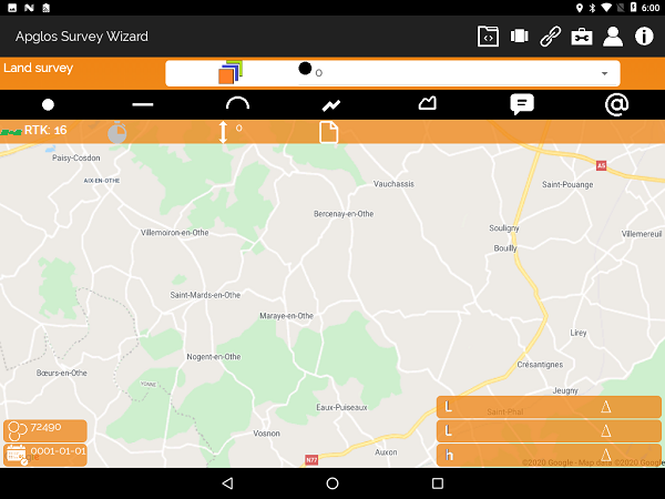
Dat moet dus RTK zijn om nauwkeurige waarden mee te landmeten. Het mooie aan Apglos Survey Wizard is dat u namelijk niet kunt meten met een slechter kwaliteitsniveau. Bij de indicaties Float RTK, DGPS en SPS kunt u namelijk niet meten.
Hierdoor bent u ervan verzekerd dat u alleen nauwkeurige meetresultaten verzameld. En daardoor heeft u een goede en betrouwbare basis voor het vervolg van uw project. En dat leidt tot een beter eindresultaat, waarbij u ook nog eens kosten bespaard.
Hoe wordt het verschil in nauwkeurigheid tussen een GPS navigatiesysteem en GPS meetapparatuur verkregen?
Alleen heb ik eerder beschreven dat hulpmiddelen nodig zijn om de centimeter nauwkeurigheid (RTK) te kunnen verkrijgen met GPS meetapparatuur.
De atmosfeer is een storende factor voor de satellietsignalen. Daarom moet bij het gebruik van GPS meetapparatuur de satellietsignalen vergeleken worden met de satellietsignalen op een vast punt.
Op het vaste punt staat ook een GPS ontvanger. De satellietsignalen die de GPS ontvanger op het vaste punt ontvangt worden vergeleken met de satellietsignalen van de GPS ontvanger in het veld. De positie van de GPS ontvanger in het veld wordt dan gecorrigeerd aan de hand van deze vergelijking.
Zo berekent met een nauwkeurige positie met behulp van GPS meetapparatuur. Hierbij geldt wel dat hoe korter de afstand is tussen de GPS ontvanger op het vaste punt en de GPS ontvanger in het veld, hoe beter de correctie is en hoe nauwkeuriger de positiebepaling is.
Deze vergelijking kan eigenlijk op twee manieren worden gedaan. De eerste is met behulp van NTRIP. Hierbij maakt de GPS ontvanger via internet verbinding met een aantal GPS ontvangers op diverse vaste punten. Op basis van de positie van het de GPS ontvanger in het veld wordt de afstand tot de verschillende vaste punten bepaald. Van de GPS ontvanger op het vaste punt die het dichtst bij de GPS ontvanger in het veld is krijgt u dan de correcties.
Een andere manier is zelf een basis opstellen. Een basis is een GPS ontvanger die langer op één plaatst staat, waardoor deze exact en nauwkeurig de positie kan bepalen. Ook met deze basis kunnen de satellietsignalen van de GPS ontvanger in het veld worden gecorrigeerd, waardoor een nauwkeurige positie kan worden bepaald.
In de bovenstaande video kunt u zien hoe u de rover basis oplossing kunt instellen om nauwkeurig met GPS te kunnen meten.
Slotconclusie over Hoe nauwkeurig is GPS?
Dit was een heel artikel over Hoe nauwkeurig GPS is. Er is veel over dit onderwerp van GPS landmeten te melden. We hopen dan ook dat u er in ieder geval een aantal zaken van heeft opgepikt en dat u daar u voordeel mee kunt doen.
Echter is alles wat in dit artikel is geschreven theorie. Als u deze theorie in de praktijk wilt brengen dan kan dat.
U kunt namelijk via deze website een GPS meetsysteem proberen of kopen. Wanneer u dat doet dan kunt u wat u door het lezen van dit artikel over hoe nauwkeurig GPS is direct in de praktijk brengen. En u kunt zien of het werken met onze GPS meetapparatuur iets voor u is.
Natuurlijk krijgt u wanneer u één van onze GPS meetsystemen probeert of koopt nog een korte en duidelijke uitleg, zodat u direct ermee aan de slag kunt.
Mocht u eerst een demonstratie willen dan kunt u die ook via de hierboven genoemde pagina’s aanvragen. Bij een demonstratie of een korte uitleg kunt u ook nog specifieke vragen stellen over hoe nauwkeurig GPS is.


 Demo inplannen? Dat kan via WhatsApp!