Landmeten bestaat uit meten of uitzetten. Het wordt soms ook maatvoeren en uitzetten genoemd. Meten en uitzetten is de basis van alle bouwprojecten in Nederland. Door goed te meten en uit te zetten kunnen nieuwe bouwprojecten precies in de bestaande situatie worden ingepast.
Meten en uitzetten zijn belangrijke onderdelen binnen de landmeetkunde. Bij meten, dat men ook wel maatvoeren noemt, wordt de bestaande situatie in kaart gebracht. En uitzetten is het markeren van vooraf bepaalde coördinaten in het veld, zodat op basis van deze punten bouwprojecten kunnen worden aangelegd en geconstrueerd. Meten en uitzetten kan op verschillende manieren. Het kan bijvoorbeeld met een meetband of met een total station. Maar steeds meer meet men en zet met uit met GPS. Behalve een goed GPS meetsysteem is het voor het meten en uitzetten met GPS handig om een tekenprogramma te hebben, waar de metingen verder mee kunnen worden uitgewerkt en waar de elementen die moeten worden uitgezet kunnen worden voorbereid.
Om alles duidelijk te maken over dit onderwerp zullen we in dit artikel de volgende vragen beantwoorden:
- Wat is meten en uitzetten?
- Waar is meten en uitzetten voor nodig?
- Welke methoden zijn er voor meten en uitzetten?
- Hoe kan men meten en uitzetten met GPS?
- Wat is er naast een GPS systeem nog meer nodig om te kunnen meten en uitzetten?
Meten en uitzetten: de oplossing
Het kan zo zijn dat u niet in de gelegenheid bent om dit gehele artikel te lezen. Daarom is er nog een mogelijkheid om meer te weten te komen over meten en uitzetten.
U kunt via deze website een GPS meetsysteem proberen. Kijk daarvoor direct op deze pagina.
U kunt op dezelfde pagina een demonstratie aanvragen van één van onze GPS meetsystemen. Bij deze demonstratie kunt u dan ook gerichte vragen stellen over meten en uitzetten en natuurlijk ook over andere onderwerpen met betrekking tot GPS landmeten.
Mocht u geen tijd hebben voor een demonstratie of wilt u snel tussendoor de software van onze GPS meetsystemen proberen dan is dat mogelijk. Apglos Survey Wizard is de eenvoudigste software om GPS metingen mee uit te voeren. U kunt deze gratis downloaden van de Google Play Store.
De landmeetapp Apglos Survey Wizard heeft volledige functionaliteit met de GPS van uw Android apparaat. U kunt deze app dus volledig testen en het is gratis.
Natuurlijk is de nauwkeurigheid van onze GPS ontvangers beter dan die van de standaard Android apparaten. Mocht u dus een test willen doen met een nauwkeurig systeem, kijk dan op deze pagina.
Wat is meten en uitzetten?
Wat is meten?
Landmeten bestaat uit meten en uitzetten. Een ander woord voor meten is maatvoeren. Meten is niet alleen het opmeten van afstanden, lengten en oppervlakten. Nee, bij landmeten is het belangrijk, dat wat er gemeten wordt, wordt gemeten ten opzichte van andere punten.
Daarom werkt men bij landmeten met coördinaten. In Nederland gebruikt men RD coördinaten. Over RD coördinaten kunt u in dit artikel meer lezen.
Het meten met coördinaten zorgt ervoor dat de positie van een object wordt vastgelegd ten opzichte van andere objecten. De gemeten objecten worden eigenlijk in kaart gebracht.
Bij objecten kunt u denken aan bomen, maar ook aan bijvoorbeeld gebouwen, wegen, lichtmasten, prullenbakken. Eigenlijk alles wat u buiten ziet wordt wel gemeten.
Na het meten van deze objecten gaat de meting naar binnen. Binnen op kantoor maakt men dan een complete kaart of ondergrond van alles wat gemeten is.
Wat is uitzetten?
En naast meten is er nog uitzetten. Uitzetten is eigenlijk precies het tegenovergestelde van meten. Waar men bij meten van de objecten buiten naar een kaart gaat, daar gaat men bij uitzetten van een kaart of ontwerp naar het markeren van de locatie in het veld.
Op het moment van uitzetten is het object vaak nog niet in het veld. Door de locatie te markeren kan men later op de gemarkeerde locatie het object plaatsen. Dit object kan ook weer van alles zijn. Hierbij kunt u wederom denken aan bomen. Maar ook bouwkuipen, watergangen, verhardingen worden uitgezet.
Het markeren gebeurt vaak met piketten, spijkers of met verf. Het type markering wordt bepaald op basis van de ondergrond. Bij het plaatsen van markeringspunten in het zand is het niet handig om met spijkers of met verf te werken. Het is namelijk de bedoeling dat na het uitzetten het markeringspunt toch enige tijd zichtbaar blijft. En met spijkers en verf op zand is dat niet het geval.
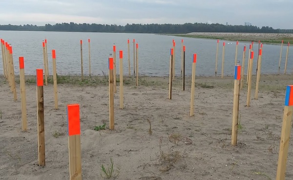
Zelfs met houten piketten is er regelmatig het probleem dat deze tijdens de bouwwerkzaamheden omver gereden worden. Dit gebeurt voornamelijk wanneer er veel materieel op het werk aanwezig is.
Uitzetten moet daarom regelmatig overnieuw worden gedaan. Het is daarom handig om een GPS meetsysteem op het werk te hebben, zodat de markeringspunten snel opnieuw geplaatst kunnen worden, nadat deze om welke reden dan ook niet meer zichtbaar zijn.
Waar is meten en uitzetten voor nodig?
Nederland is voortdurend in ontwikkeling. Dit betekent dat er continu gebouwd wordt. En wanneer er een nieuw bouwwerk of een weg moet komen, dan moet deze natuurlijk wel passen in de bestaande situatie.
Daarom is het meten en uitzetten enorm belangrijk. Door het meten ontstaat een kaart of ondergrond die de basis is van een ontwerp van een bouwwerk, weg of een tuin.
De ontwerper past het nieuwe ontwerp in op deze ondergrond. En wanneer het ontwerp gereed is en de uitvoering begint, dan komt er het uitzetten. Door het uitzetten wordt er voor gezorgd dat het ontwerp op de juiste positie in het veld wordt aangelegd.
Het meten en uitzetten is dan ook enorm belangrijk voor het inpassen van nieuwe werken in de bestaande situatie. En het meten en uitzetten komt in vele disciplines voor. Zo kunt u denken aan de grond-, weg- en waterbouw sector. Maar u kunt ook denken aan bouwaannemers, hoveniers en alle partijen die aan beheer van buitenruimten doen.
Voor het beheer is namelijk na de uitvoering nog een meting belangrijk. Dit is de revisiemeting. Bij een revisiemeting wordt alles wat nieuw is aangelegd in kaart gebracht. Op basis van deze kaart kan een beheerder op een later tijdstip beslissingen maken.
Welke methoden zijn er voor meten en uitzetten?
Het belang van meten en uitzetten mag duidelijk zijn. Maar er zijn wel verschillende methoden voor meten en uitzetten.
Meten met een meetlint
Ten eerste is er het oude meetlint. Het meetlint is makkelijk te gebruiken. U zet het meetlint vast op een bekend punt en leest de afstand af op het meetlint bij het object dat u wilt meten. Wanneer u dat voor hetzelfde object doet van verschillende bekende punten, dan kunt u het object vastleggen ten opzichte van deze bekende punten.
Het meten en uitzetten met een meetlint heeft wel een aantal nadelen. Het resultaat van een meting met meetlint zijn afstanden ten opzichte van bekende punten en dus niet de gewenste coördinaten. U kunt alleen de coördinaten achterhalen wanneer de coördinaten van de bekende punten goed zijn vastgelegd.
Daarnaast dient bij een goede meting het meetlint altijd strak te zijn, wanneer u deze afleest. Dit is niet altijd mogelijk. Daardoor neemt de onnauwkeurigheidsfactor toe. Ook met de hoogten houdt het meten en uitzetten met meetlint geen rekening.
Kortom het meten en uitzetten met een meetlint is goed voor een indicatie, maar het is niet nauwkeurig en het werkt ook niet echt snel.
Landmeten met een total station
Gelukkig zijn er ook andere methoden om mee te meten en mee uit te zetten. Één daarvan is de total station. Een total station werkt met hoeken en afstanden. Deze gaat net als een meetlint uit van bekende punten.
Net als bij het meetlint is het bij metingen en het uitzetten van punten met een total station belangrijk dat de coördinaten van de bekende punten goed zijn.
Wanneer deze goed zijn dan kan het resultaat van een total station op de millimeter nauwkeurig zijn. Echter wanneer de coördinaten van de bekende punten niet correct zijn, dan werkt de foutmarge van zo’n basispunt door de gehele meting door.
Het landmeten met een total station is ook een vak. Voordat iemand met een total station overweg kan, moet hij hiervoor goed zijn opgeleid. En dit is niet iedereen.
Het meten en uitzetten met een total station kan alleen tot goede resultaten leiden, wanneer het wordt uitgevoerd door vaklui.
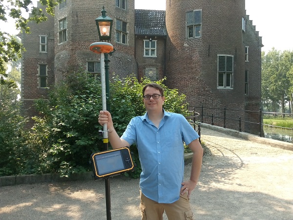
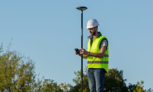
Landmeten met GPS
Helaas zijn vaklui, die met een total station overweg kunnen, schaars. Gelukkig is er ook nog een mogelijkheid om te meten en uit te zetten met GPS.
GPS is enorm eenvoudig voor positiebepaling. Iedereen gebruikt het voor navigatie. Wanneer het om centimeternauwkeurige positiebepaling gaat is GPS iets ingewikkelder.
Maar Apglos heeft het met de landmeetapplicatie Apglos Survey Wizard zeer eenvoudig gemaakt. Hierdoor is het meten en uitzetten met GPS nu door iedereen toegankelijk. U kunt Apglos Survey Wizard zelf downloaden uit de Google Play Store.
Bij GPS meten werkt een fout in een eerder gemeten punt niet door in de rest van het resultaat. Ook is het opstellen van GPS meetapparatuur veel sneller dan het opstellen van een total station. Er zijn dus veel voordelen van GPS meetapparatuur ten opzichte van een total station.
Er zijn echter ook een paar nadelen. Alleen wanneer het GPS systeem voldoende satellietsignalen ontvangt dan kan u met een GPS systeem meten en uitzetten. Met GPS kan dus niet in tunnels en onder viaducten worden gemeten.
Gelukkig komen er steeds meer satellieten, die GPS ontvangers kunnen gebruiken om de positie te bepalen. Toch blijft de maximale nauwkeurigheid van GPS op centimeter niveau. Dit is wat minder dan met een total station. Maar voor de meeste toepassingen van meten en uitzetten is GPS zeer geschikt.
Hoe kan men meten en uitzetten met GPS?
Meten en uitzetten met GPS is dus de beste oplossing. Het is nauwkeurig tot op de centimeter en het is makkelijk in gebruik.
Een GPS meetsysteem bestaat uit een GPS ontvanger, een GPS meetstok, een tablet, een tablethouder, wat accessoires. Echter het belangrijkste is de software. Met de software bedient u het gehele meetsysteem.
De software moet dus makkelijk in gebruik zijn. En daarom zit bij al onze GPS meetsystemen de landmeetapp Apglos Survey Wizard. Deze app maakt het toegankelijk om te meten en uit te zetten met GPS.
Maar hoe werkt meten en uitzetten met GPS nu precies? Het is vanzelfsprekend om alle onderdelen aan te zetten en Apglos Survey Wizard aan te zetten. Dan moet er verbinding worden gemaakt tussen Apglos Survey Wizard en de GPS ontvanger. In de onderstaande video ziet u de uitleg van het verbindingsscherm van Apglos Survey Wizard.
Nadat er een verbinding is, is het meten erg makkelijk. In de onderstaande video ziet u de uitleg van het meetscherm van Apglos Survey Wizard.
En dan is er nog het uitzetten. Bij het uitzetten moet u ervoor zorgen dat de uit te zetten objecten in Apglos Survey Wizard komen te staan. Dit kan door een DXF-, TXT-, CSV-bestand te openen. Maar u kunt ook zelf handmatig coördinaten uitvoeren.
Daarna kunt u op het uitzetscherm de objecten selecteren. Aan de linkerkant van het scherm ziet u een pijl met de richting naar het punt. En daaronder ziet u de afstand tot het punt en het hoogteverschil met het punt.
U hoeft dan alleen zo te lopen dat de afstand gelijk is aan 0. Zoals u kunt lezen is het zeer eenvoudig. En zo werkt meten en landmeten met GPS.
Wat is er naast een GPS systeem nog meer nodig om te kunnen meten en uitzetten?
Hierboven staat in het kort beschreven hoe u kunt meten en uitzetten met GPS. U heeft daar dus een GPSS meetsysteem voor nodig.
Maar het is handig als u nog meer heeft. Voor het meten is het van belang dat de meting wordt omgezet naar een duidelijke tekening. Natuurlijk werkt Apglos Survey Wizard met lagen. En met deze landmeetapp kunt u de meetgegevens opslaan als DXF.
Hierdoor zijn de meetgegevens van Apglos Survey Wizard makkelijk te gebruiken in tekenprogramma’s als Microstation en AutoCAD. Natuurlijk zijn er ook andere tekenprogramma’s die u kunt gebruiken.
Als u echt het optimale uit een GPS systeem wilt halen voor meten en uitzetten dan is een tekenprogramma noodzakelijk. Door een tekenprogramma kunt u namelijk de meetgegevens verder uitwerken.
Daarnaast is een tekenprogramma bij het uitzetten ook erg handig. Met een tekenprogramma kunt u namelijk de objecten in een bestand plaatsen, die u met uw GPS systeem met Apglos Survey Wizard makkelijk kunt uitzetten.
Wel moet u weten dat u geen professioneel tekenaar hoeft te zijn. U hoeft alleen de basis van het tekenprogramma te weten. Hiervoor kunt u bij ons ook een cursus volgen.
Vraag daarvoor naar de mogelijkheden.
[contact-form-7 id=”913″ title=”Contact”]
Naast het tekenprogramma heeft u voor het uitzetten ook nog markeringsmateriaal nodig, zoals piketten, spijkers of verf. En natuurlijk heeft u gereedschap nodig om het markeringsmateriaal aan te brengen.
Maar dat is dan ook wel alles. Om zelf te gaan meten en uitzetten met GPS heeft u dus niet veel nodig.
Slotconclusie over meten en uitzetten
Dit was een heel artikel over meten en uitzetten. Er is veel over dit onderwerp van GPS landmeten te melden. We hopen dan ook dat u er in ieder geval een aantal zaken van heeft opgepikt en dat u daar u voordeel mee kunt doen.
Echter is alles wat in dit artikel is geschreven theorie. Als u deze theorie in de praktijk wilt brengen dan kan dat.
U kunt namelijk via deze website een GPS meetsysteem proberen of kopen. Wanneer u dat doet dan kunt u wat u door het lezen van dit artikel over meten en uitzetten direct in de praktijk brengen. En u kunt zien of het werken met onze GPS meetapparatuur iets voor u is.
Natuurlijk krijgt u wanneer u één van onze GPS meetsystemen probeert of koopt nog een korte en duidelijke uitleg, zodat u direct ermee aan de slag kunt.
Mocht u eerst een demonstratie willen dan kunt u die ook via de hierboven genoemde pagina’s aanvragen. Bij een demonstratie of een korte uitleg kunt u ook nog specifieke vragen stellen over meten en uitzetten.


 Demo inplannen? Dat kan via WhatsApp!